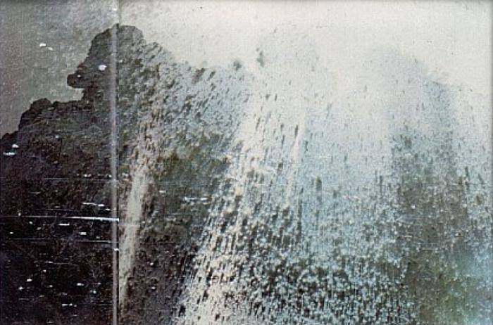
| ▲ | Kilauea erupts, destroying webcam [video](youtube.com) |
| 228 points by zdw 6 hours ago | 53 comments |
| |
|
| ▲ | whyage 5 hours ago | parent | next [-] |
| Hawaiʻi Volcanoes National Park is absolutely stunning (and safe, away from the closed area). It's like being on a different planet. If you haven't been to the Big Island and the park, you should add it to your bucket list. |
| |
| ▲ | ridgeguy 3 hours ago | parent | next [-] | | Decades ago, my wife and I visited the Big Island during a fairly sedate eruption. We drove down Chain of Craters Road, got to see a tiny lava flow (talking like a couple feet of glowing honey), but were wanting more. In the distance, we could see a huge steam column where a lava stream was reaching the sea. We asked one of the ever-attendant Park Rangers if we could walk over there. He said no. But then he said - we close at 5pm, and there are no gates. OK, we can take a hint. We drove to Hilo and bought cheap tennis and flashlights, then scurried back down Chain of Craters after 6. As the sky darkened, we walked towards the steam column. The rocks beneath our feet showed incandescent glows deep in the cracks, and we started to smell burned rubber from our cheap tennis. Eventually, we came to the lava outfall. We watched nearly an hour as a river of molten rock cascaded into the ocean. We used our water bottles on our shoe soles, turning back when we ran dry. I now understand that we were stupid - apparently the park loses a few tourists to shelf collapse each year - but we lived, and the memory is a treasure. Thank you, Mr. Ranger. And yes, it's like being on a different planet - like being on our own, maybe 4 billion years ago. | | |
| ▲ | 14 2 hours ago | parent [-] | | Not stupid. Just experiencing life and sometimes amazing experiences have a chance of danger. You get to choose what risk levels you are okay with. Props to that ranger who agreed with that belief. | | |
| ▲ | kbenson an hour ago | parent | next [-] | | Choosing your risk level and working within it isn't stupid. Not knowing the risk when it's easy to gather some more info and then acting in ignorance is, which is what GP was describing, and likely why they called their own actions stupid. | |
| ▲ | ridgeguy 2 hours ago | parent | prev [-] | | At that time, we had no kids & no pets, nobody directly dependent on us. That figured in our conversation on the drive to Hilo. Nowdays, we might come to a different conclusion, but I'm glad for the path we chose then. | | |
|
| |
| ▲ | spike021 10 minutes ago | parent | prev | next [-] | | As postal mentioned below, Haleakalā is fantastic for that. Also, I recently visited Mt. Aso in southern Kyushu of Japan and it really felt like I was on Mars. | |
| ▲ | postalcoder 43 minutes ago | parent | prev | next [-] | | Haleakalā is like this as well. Don't just drive up the crater - hike through the thing. It's a ~12 mile hike. It's a remarkable experience because the landscape changes so frequently and dramatically from desert to tropical forest. The only comp to this is like the transition in Max Max from the desert to the oasis. Tourists that drive to the crater, take pictures, and drive down have no idea what they're missing. | |
| ▲ | anonymousiam 38 minutes ago | parent | prev | next [-] | | Went there a little over a year ago. The steam vents were active, but no eruptions. The exhibits are wonderful and the birdsong in the evening is amazing. | |
| ▲ | magicalhippo 4 hours ago | parent | prev [-] | | Sadly there was an ongoing eruption when me and my SO visited the Big Island, so the entire park was closed. Was a bit bummed out, on the other hand people lost their homes so keeping it in perspective. That said, I second visiting the Big Island and visit various sites. Driving less than an hour and going from barren volcanic landscapes to lush rainforests was something else, and watching the sunset from Mauna Kea was magical. And lots of great beaches, and most that weren't next to a resort had very few people. While the island is big relative to the other Hawaiian islands, its small enough that you can drive around it in a day. I'd recommend staying on the Kona side, which is the dry and somewhat barren side. The Hilo side has rainforests for a reason. | | |
| ▲ | DavidPeiffer 2 hours ago | parent | next [-] | | What struck me about the big island is that it has 8 of the 13 climate zones, and you can go around the perimeter of the island in about 5 hours. I loved going up Mauna Kea visitor center and stargazing. At ~11,000 feet, it's one of the best places in the world for naked eye stargazing. You're literally above the clouds, the island has strict rules about exterior lights at night to minimize light pollution, and you're above the thickest air. I wasn't expecting to see the Milky Way so easily. https://en.wikipedia.org/wiki/Milky_Way#/media/File:Milky_Wa... | |
| ▲ | skybrian 3 hours ago | parent | prev | next [-] | | The Big Island has good B&B's in many parts of the island so I recommend staying in multiple places, to see the local sights without a long drive afterwards. | |
| ▲ | shevy-java 4 hours ago | parent | prev [-] | | A university professor here visits many areas. He complained by far the most of the dust in the air that stuck around for quite a while there. |
|
|
|
| ▲ | emmelaich 2 hours ago | parent | prev | next [-] |
| I had a look at the crater using Google maps. Does this user contributed photo look AI to anyone? Or at least 'shopped. https://maps.app.goo.gl/or6gj5XnTCTwv4Ys7 |
| |
| ▲ | jcranmer an hour ago | parent | next [-] | | That photo is pretty clearly fake. * The steam from lava should be arising from where the lava hits the lava, boiling it--there's not going to be any steam from the interior of a lava tube, because all of the water will have boiled out long ago. * It looks like somebody dumped a photo of a black rock field on top of a different image. There's a sploch of a normal tan-sand beach at the base of part of this cliffs; in recent lava activity, the lava will extend fully into the ocean and collapse. Given that the edge of the lava is a) pretty towering and yet b) some distance from the sea. * The lava activity in the extreme foreground is pretty sketchy. It's not entirely implausible to have lava flowing into a pit like that in some fashion, but there's also no clear source from the lava, and real Hawaiian lava flows tend to look somewhat different than that. * Lava flows downhill from a rift zone. Where's the rift zone here? It's basically a wall of black rock. Photogammetry is not my strong suit, but the presumably dried lava is towering above the treetops in the distance, and yet there's no clear sense of where the lava is flowing from. * In the background, you see something more akin to a stratovolcano (actually, might well be an eroded granite dike or some other weird formation like that as opposed to a volcano in the first place). Hawaiian volcanoes are shield volcanoes, they don't look like that. Also, Kilauea and Mauna Loa are too active to really have the deeply-eroded look like that. You have to go to Kohala on the Big Island to get that kind of look. * Kilauea is nowhere near the ocean. (Also, shield volcano, you can't see the top from the base.) * There's another island clearly visible in the background. None of the Hawaiian islands are close enough to each other to generally be visible from one another! And certainly not from any view of Kilauea, which is the last volcano in the chain that's above sea level. (Loihi still has another 3,000 feet to go before it pokes above the surface.) | | |
| ▲ | pfdietz 35 minutes ago | parent [-] | | Not saying this isn't fake, but erupting lava produces plenty of volatiles, including steam. These gases coming out of solution is what drives it to the surface. |
| |
| ▲ | dawnerd 30 minutes ago | parent | prev | next [-] | | There's a lot of really spammy data on Google maps that should be pretty easy for them to detect too. Go look at some remote locations and you'll find lots of images that advertise businesses, products and all sorts. Wondering if they're using it for image hosting. | |
| ▲ | AstroNutt 2 hours ago | parent | prev | next [-] | | Nothing looks right. The waterfall of lava to the caldera. How do you get magma ring above a non erupting caldera? It's 100% fake. | |
| ▲ | IAmGraydon an hour ago | parent | prev | next [-] | | That user has submitted 58,000 photos. It's AI. Everyone should be reporting the photo and the account. | |
| ▲ | pimlottc 2 hours ago | parent | prev | next [-] | | It’s not real, lava has not flowed into the ocean for many years. | |
| ▲ | csomar 2 hours ago | parent | prev [-] | | Are these giant buildings over there? Would be easy to check their existence (though the photo could be real but the lava is not) |
|
|
| ▲ | accrual 4 hours ago | parent | prev | next [-] |
| It's wild to see this footage safely behind a monitor. Kind of macabre to ponder but I wonder if the victims of Pompeii had a similar experience. The last we see is a hailstorm of ash and molten lava raining down then signal lost. |
| |
| ▲ | fsckboy 2 hours ago | parent | next [-] | | there is a poignant set of images taken by a photographer Robert Landsburg who chose to post himself too close to the blow up of the top of Mount Saint Helens in 1980. the last picture from his salvaged camera is similar to what we see for this topic: https://allthatsinteresting.com/wordpress/wp-content/uploads... his camera was found under this body, with speculation that he was protecting it, which doesn't seem unlikely, but it also would not be surprising for him not to have had that presence of mind, things were happening very quickly. https://allthatsinteresting.com/robert-landsburg | |
| ▲ | toss1 3 hours ago | parent | prev [-] | | iirc, Pompeii was a pyroclastic flow [0], a fast-moving current of hot gas and volcanic matter with speeds between 100-700 km/hr and temperatures up to 1000°C. So, probably something like that, but a lot bigger, faster, and arriving faster from further away. I was surprised how long the camera lasted getting buried. It'd be a not good end. [0] https://en.wikipedia.org/wiki/Pyroclastic_flow | | |
| ▲ | asdfman123 2 hours ago | parent | next [-] | | Yeah, they likely saw it racing down the mountain and then met their doom fairly immediately. | |
| ▲ | fsckboy 2 hours ago | parent | prev [-] | | i just posted a sister comment to yours about the Mt St Helens explosion, with a picture from 1980, and then i noticed that they are calling (it's a non technical article) what rained down in the photograph onto the camera and photographer "pyroclastic flow" and it looks very similar to what happened here. |
|
|
|
| ▲ | hnburnsy 5 hours ago | parent | prev | next [-] |
| USGC live stream https://m.youtube.com/usgs/live |
| |
| ▲ | hnburnsy 5 hours ago | parent [-] | | Looks like the camera and stream are still active... https://m.youtube.com/watch?v=BqmpkUdMtyA | | |
| ▲ | yuliyp 3 hours ago | parent | next [-] | | Starting at 9:46 is when it goes from wow to WOW. The last 2 minutes in particular are incredible, including the bizarre artifacts in the last 15 seconds before the stream dies. | |
| ▲ | reincarnate0x14 4 hours ago | parent | prev [-] | | They have three cameras, well, had three. The south rim camera (v3) was overrun by the eruption at about 0957 local time, you can rewind the stream and watch its final moments. |
|
|
|
| ▲ | stevenhubertron 5 hours ago | parent | prev | next [-] |
| That arcing of the lava really is something to behold. The pressures to push molten rock like that are impressive. |
| |
|
| ▲ | jcranmer 5 hours ago | parent | prev | next [-] |
| Kilauea is more or less constantly erupting. This is the 38th eruptive episode since in the past year: https://www.usgs.gov/volcanoes/kilauea/science/eruption-info... (note that the 38th episode started a few hours ago as of this message). Although this is still considered "one" eruption by USGS. |
| |
| ▲ | dboreham 2 hours ago | parent [-] | | Although it will stop erupting any time I get on a plane headed there. Same for Iceland. |
|
|
| ▲ | clbrmbr 3 hours ago | parent | prev | next [-] |
| When I walked across the crater as a kid, I remember there was an inner crater that I was told had filled up with lava back in the 80s and then drained down leaving a deep well. Does someone have a map of the historical eruption locations within the main summit crater? |
| |
|
| ▲ | alex_young 3 hours ago | parent | prev | next [-] |
| Here’s a video I took of an eruption in June: https://youtu.be/BGOSSNy1hN0?si=MIFkW7MkRDxJ5tUr |
|
| ▲ | omnicognate 5 hours ago | parent | prev | next [-] |
| This was incredible to watch, and I have to chuckle at this title. It's obvious why the webcam matters, with people round the world watching, but the destruction of a webcam is such a tiny thing in comparison to the eruption itself it's strangely funny. |
| |
| ▲ | DonHopkins 4 hours ago | parent [-] | | Would be nice to have a mobile phone live streaming webcam viewer that vibrates when the webcam is destroyed! |
|
|
| ▲ | Mistletoe 5 hours ago | parent | prev | next [-] |
| The final moments of the webcam were even better than I had hoped. |
| |
|
| ▲ | shevy-java 4 hours ago | parent | prev | next [-] |
| Pretty cool - that looks like two or three eruption holes. Now someone timejump to krakatau, year 1883 ... |
| |
| ▲ | embedding-shape 4 hours ago | parent [-] | | If we're lucky, we (humanity) get to experience another supervolcano eruption sometime in the future, and then we'll finally get some good content out of it. | | |
| ▲ | avalys 3 hours ago | parent [-] | | Personally I’m looking forward to a nearby supernova or giant meteor impact! |
|
|
|
| ▲ | nickpsecurity 5 hours ago | parent | prev | next [-] |
| The threat level for airplanes is set to orange... for anyone dumb enough to fly over an erupting volcano. The orange flying from the ground would be all the motivation I need to stay clear of it. It was an awesome video, though. |
| |
| ▲ | jcranmer an hour ago | parent | next [-] | | An erupting volcano can spew ash over a large distance. When Eya.... that Icelandic volcano (that's hard to spell because I don't know Icelandic) erupted several years ago, the ash cloud traveled far enough to disrupt travel over most of Europe for a few days. | | | |
| ▲ | mschuster91 4 hours ago | parent | prev [-] | | > The threat level for airplanes is set to orange... for anyone dumb enough to fly over an erupting volcano. Even 180km away from the eruption, airplanes can be seriously damaged [1]. Jet engines really, really do not like to ingest anything else than air and, maybe, a tad bit of water. https://en.wikipedia.org/wiki/British_Airways_Flight_009 | | |
| ▲ | euroderf 3 minutes ago | parent | next [-] | | Prevailing winds are key. Reykjavíkings told me that during that big eruption many moons ago, all traffic to Europe was ended but traffic to North American continued merrily along. | |
| ▲ | avalys 3 hours ago | parent | prev [-] | | Volcanic ash is particularly bad because it is so abrasive, having been freshly formed without any opportunity for erosion to smooth it down like regular dust. | | |
| ▲ | duskwuff an hour ago | parent [-] | | That's not the only problem - volcanic ash also has a low enough melting point that it'll melt in the combustion chamber of a jet engine and leave glassy deposits on cooler components. |
|
|
|
|
| ▲ | quotemstr 2 hours ago | parent | prev [-] |
| I'd love to learn more about the specific failure mode towards the end. As the eruption debris approach the camera, we see glowing rock up close. The camera then flashes purple for some reason, goes black, then returns to streaming for a few more seconds, recording a vague orange glow. After that, it's gone for good. |